We should not be surprised, as, after all, it is mid-winter, but the first few weeks of January have seen some atrocious weather but also some good periods. As mentioned in a previous newsletter the River Dane is a high spate river, being fed from a myriad of streams up in the hills and the water level increases quite rapidly. During Jan 12th-14th, the water level at Havannah Bridge rose by approx. 1.5metres and breached the upper and lower work areas.
Despite this, the CTC Team, in the most appalling conditions managed to get the LH Waler Beam constructed and concrete poured, although all hands to the pumps next day to pump the water out! It might of course be thought that with all that water flowing over the Weir would increase the amount of power that we will be able to generate. Unfortunately, the opposite is true, as floodwater pouring over the Weir is not able to ebb away fast enough and as such the “head” (water height between top and bottom) decreases.
The power generated by the Archimedes Screw is directly related to the “head”, so we always want a decent head, commiserate with a decent flow. At low flow, our Variable Speed Drive will enable quite a decent generation. Although not yet built, the Powerhouse, containing all the equipment will be above such high-water levels.
For your interest and information, River and Sea levels in the UK are checked regularly by a network of monitoring stations operated by the Environment Agency, Natural Resources Wales, and the Scottish Environment Protection Agency. Flood warnings and flood alerts are published whenever flooding is expected. The Flood Forecasting Centre, a collaboration between the Environment Agency and the Met Office, provides a detailed five-day flood forecast for England and Wales.
Riverlevels.uk is an independent website which draws together data from all these sources to provide a unified river levels and flood warnings map as well as detailed information for each river level monitoring station and flood warning area. The River Dane has three of these monitoring stations in the near vicinity, Upstream at Hug Bridge near Rushton, Downstream at Rudheath near Northwich and very conveniently for Congleton Hydro, a monitoring station in Congleton Park about one mile downstream.
Data from these monitoring stations can be accessed via:
River Dane at Congleton Park :: the UK River Levels Website
The highest water level recorded for the River Dane in Congleton Park was in 1995. This resulted in the water level lapping the parapet at Havannah Bridge. Of course, being a spate river, the water level also falls quite rapidly as the weather conditions improve. A snapshot of the water levels on January 31st is shown below.

As mentioned earlier, despite some appalling weather conditions, leading to even worse ground conditions (giant-sized wellies needed!!!!) CTC has made some excellent progress, and we move closer and closer to the big day of installing Archie the Screw.
Key activities during January:
- Piles driven in to support the hillside (to prevent it slipping onto screw channel)
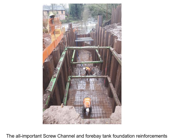
- Channels excavated, base foundations laid, and concrete poured to form the waler beams for both the upper and lower screw channel sides (significant milestone as the waler beams provide the all-important lateral strengthening to the piled sides.
- Load distribution props installed. (These distribute some of the load from the upside piles to the lower side, to help compensate for the reduced base toe due to the higher-than-expected rock levels)
- These activities then allowed the excavation of the actual screw channel and the ground excavation for the forebay tank.
- Finally, the reinforcement of the forebay tank floor has been laid (as a reminder, the forebay tank is the chamber that connects the inlet water pipe to the head of the Archimedes screw and gives some degree of flow smoothing and fine debris settlement.


During February (last week of winter!!!!) the main activities are:
- Complete forebay tank (base, walls, and roof slab)
- Lift and install the Archimedes Trough and Screw—–this is the culmination of all the hard work over the past months. The actual date of the lift and install depends on completion of the forebay tank and especially the “hardening” of the concrete base, dependent on weather, up to seven days hardening will be needed.
- Lay coupling lengths of the inlet pipe to screw excavation.
- Once the screw is in place, the gearbox and generator plinth frame can be constructed, and concrete poured (precision required to get angles exactly correct so that gearbox shaft lines up precisely with screw shaft.)
So, February is a key milestone month – please, please let the weather be kind.
Waler Beams
As you note from the photos and the text, Waler beams are an important element of the design and construction of the screw channel. We have had a few queries as to exactly what is a Waler Beam?
What does it do? and why is called a Waler Beam? Wiktionary states: “Basically it is a plank of wood, metal bars, a block of concrete etc used to support or to maintain the required separation between components in order to help maintain the form of a construction under stress”. ……” it is a horizontal beam attached by some means to a larger upright structure – often used on retaining walls, docks etc. To maintain alignment and to receive stabilising props across open excavations.” In our case, these waler beams are formed from poured concrete over re-enforcing steel rebar and are used to give lateral stability to the piles.
Great, we now know what they are and what they are used for, but why not just call them re-enforcing beams?
Nautical English has been using “wale” words since Middle English (in this case around the 13th century) for planks or timbers forming the sides of a boat or ship i.e., the longitudinal/lateral timbers that run fore and aft. A wale is typically a plank, especially the topmost plank running along the topsides and would help stiffen the boat to receive blows when docking or being rammed by other craft. (Best guesses about origin point to Old English words (around the 9th century) for a weal left on the skin by a blow from example a stick, and for a ridge or bank of earth.
Waler boats tend to have a continuous line of planking that is made distinct from the other lines of planking by being a different colour or size. This is quite often called a Wale Strake and again it has been in used in nautical English since Middle English of around the 14th century. A wale strake of distinctive colour has been a feature of boat decoration in several different cultures around the world at different times and continues currently.
Moving on to the Boardwalk, progress has been steady but slow. Again, hit by the weather but more so by COVID. Redfox is a son and father team who are also having to take up their children’s distance learning supervision during this current lockdown period. So, it is, in essence, one week on and one week off as it is not easy and certainly not safe to have one person working. Overall progress however broadly fits in with the main construction plan and is within sight of the finishing line.
The Boardwalk, as well as being the access for maintenance, is an essential element of the education and visitor programme. The Education programme volunteers are making some excellent progress in identifying relevant modules and potential content. A future edition of the newsletter will cover Education in more detail, in the meantime, the graphic below shows how the core themes fit together.

Along the boardwalk, suitably positioned, will be four “interpretation boards” that will cover the core content of each of the themes i.e. The Hydro System, The Industrial Heritage especially that of the energy utilisation over the centuries, The River—the source of all the power and The Ecology of the site and its surroundings. QR codes will be present on each board that will enable suitable readers e.g. mobile phones to access the substantial details of the topic via the Congleton Hydro website.
A fifth Interpretation Board will be positioned at the entrance to the site. This will cover what Congleton Hydro is, how it works, how it was funded and how its performance will enable community environmental projects to be funded on an annual basis.
An early draft outline of the “Rivers Interpretation” Board, is shown below.

As regular readers will know, we try to include a more detailed “topic of interest” with each issue.
This month’s “Topic of Interest” focuses on the Planning and Approvals process. Whilst we guess that most will not be planning on the construction of micro–Hydro System in your back garden, the process and experiences we went through, will maybe of value to any people or organisation thinking about realising a community interest project. (Although having said that, there are several small weirs situated on private properties in the area that would be eminently suitable for a small hydro generation scheme, whether they can be financially viable is another matter!).
During the long process, we found that it was of great value to seek advice and to harness the experience and knowledge of the planning and approval authorities. We thank them for their cooperation. Even though you will not in all probability be contemplating any such project, we hope you will find the article interesting.
We hope you have found this newsletter to be informative and of interest. It is intended to give you a picture of how the scheme is proceeding and the obstacles (especially the weather!) that sometimes must be overcome. We would welcome your feedback and any topics you might like to see in future issues. Please drop us a line at info@congletonhydro.co.uk
Stay Safe and Take Care.
I noted in your original Project Funding that you required 670k but raised 700k+.
Are you still confident that the project can be completed within this estimate considering the disruption.
Also could you advise the mechanical costs of the screw and gearbox.
Thanks for your interest in the project, yes we did exceed the original funding target. Due to COVID delays which forced the build of the project over the winter months, not ideal when building next to a river! Extra costs/delays have been incurred. However, the project is on track and the construction phase due to be completed end of March/beginning of April which is still within the contingency funds. Let me check on the costs of the screw and gearbox. Thanks Cathy
Archimedes Screw (with installation) £92,647
Electrical Equipment and Installation £56,300
There are a breakdown of costs in the original share document http://congletonhydro.co.uk/wp-content/uploads/2020/10/ShareOfferDocument.pdf
p22. Thanks